
Reservoir of fly fishing
Latournerie Lake
Access to Lake
 fr.wikipedia.org/wiki
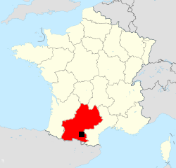
Latournerie Lake is located in the Midi-Pyrénées in Ariège at the edge
of the Languedoc-Roussillon and the departments of Aude and
Haute-Garonne. It is near the major cities of Occitan and Catalan
countries :
| Foix | 40 km | Auch | 170 km | ||
| Carcassonne | 52 km | Montpellier | 200 km | ||
| Toulouse | 92 km | Rodez | 237 km | ||
| Narbonne | 113km | Barcelone | 276 km | ||
| Montauban | 145 km | Pau | 280 km | ||
| Albi | 164 km | Marseille | 304 km | ||
| Perpignan | 165 km | Lyon | 496 km |
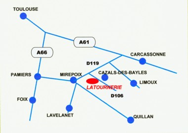
The lake is located east of the town of Mirepoix, about 5 minutes by car.
From Mirepoix take the direction of Carcassonne by the D119. After about 2.5 km, turn on the right towards Cazals of Bayles.
By the A61 motorway, exit Bram towards Mirepoix.
By the A66 motorway, exit Pamiers towards Mirepoix.
To calculate your route : http://www.viamichelin.fr
To locate the lake with Google Maps
Weather Lake
Weather
in Mirepoix